Friday, March 14, 2014


NAME : SITI NUR NABILA BINTI AWANG

MATRIC NO : A11A428

FACULTY. UNIVERSITY : FACULTY OF ENTREPRENEURSHIP AND BUSINESS                                                                   
DATE OF BIRTH : 1 JULY 1992

PLACE OF BIRTH : HOSPITAL UNIVERSITI SAINS MALAYSIA, KOTA BHARU

AREA OF STUDY : BACHELOR OF ENTREPRENEURSHIP AND BUSINESS (COMMERCE)                    

AMBITION : LECTURER

EVALUTION OF THIS ASSIGNMENT : 

I ABLE TO KNOW LOT OF INTERESTING AND BEAUTIFUL PLACES ALL OVER THE WORLD SINCE I DO SOME RESEARCH ON IT AND SEE THE PICTURES. THIS BLOG ASSIGNMENT GIVE ME THE OPPORTUNITY TO KNOW 15 BEAUTIFUL PLACES AND THE TOURIST ATTRACTION AND ACTIVITIES AT THAT PLACE. 

Wednesday, March 12, 2014

UNITED STATES

MENDENHALL GLACIER

JUNEAU, ALASKA, US

The Mendenhall Glacier is a tongue of ice stretching 12 miles from the Juneau Icefield to Mendenhall Lake. At its widest point, the glacier is more than a half mile wide, with ice 300 to 1,800 feet deep. The Mendenhall is one of 38 large and more than 100 smaller valley glaciers in the Juneau Icefield. The larger Taku, Eagle, and Herbert Glaciers are also nearby.

In 1879, naturalist John Muir named it "Auk Glacier" after a local Tlingit Indian village. In 1892, the name was changed to honor Thomas C. Mendenhall, superintendent of the U.S. Coast and Geodetic Survey. Since the mid-1700s, the glacier has been retreating. Before 1765, the face of the glacier reached 2.5 miles farther down the Mendenhall Valley.


Glacial ice has a unique crystalline structure that absorbs and reflects light, giving the ice its blue appearance. The most intense blue occurs in crevasses and when ice breaks off, or calves, from a glacier's face. The blue color fades as the ice is exposed to air and the crystalline structure breaks down. In Alaska, glacier viewing is often best on overcast and rainy days.

MENDENHALL GLACIER TREK


Trace the path of glacial succession as you introduce yourself to glacier trekking and the natural history of the Mendenhall Glacier! The trip begins with a three and a half mile trail hike through the rainforest along Mendenhall Lake.


The first mile of the trail is well maintained and goes through forests with a few switchbacks, while the second two and a half miles of the trail is hiking on bedrock with rock scrambling in steep sections. This rocky terrain is challenging and very off the beaten path.


MENDENHALL ICE CAVES OF JUNEAU, ALASKA

Mendenhall, the famously 12 mile long, 150 foot deep and half mile wide glacier melts as you watch it, and moves as much as 60-70 feet per year. The massive glacial geography and its changes over time are a sight to be seen. But it’s real beauty lies beneath. Beneath the seracs of “ice peaks” all over the glacier. Beneath the trails that wind the non-touristy western half of the glacier. Under the white outer-coating of the glacial ice itself–a beautiful if only superficial “cover”–one finds a brilliantly colored world of ice caves unlike anything I’ve found anywhere else in nature.


Neither raging nor deep, there are two waterfalls that slip down the side of adjacent Mt. McGinnis in Juneau, Alaska. These gentle streams belie their real impact on the glacier. As one follows the flow of water down the mountain, it slips under the edge of the glacier where, over thousands of years, it has carved massive caves through the ice. Known by most of the locals but far, far off the tourist track, these caves were an extraordinary experience–the kind that will live with you for the rest of your life. There’s simply nothing else like it.

The path to get there is not so much difficult as it is technical–requiring balance and calculated movements more than muscle or raw perseverance. Park at the head of Western Glacier Trail. Hike the trail out to the viewing platform atop the small knoll. There’ll be a sign pointing to it. But instead of continuing along Western Glacier Trail, you’ll take the unmarked trail from the viewing platform down towards the glacier. This path is technical and moderately arduous, but not overly long. It’ll wind through Juneau’s beautiful rain forests and take you through some areas where you will need to climb over large rocks (no climbing gear is needed–the rocks are easy, just tall). From here, you’ll begin the final descent onto the glacier itself. You WILL need ice cleats or, at minimum, crampons. Climb the glacier for a while and behold the majestic beauty of the ice upfront. You can see holes that go all the way through the glacier with constantly streaming flows of water–a reminder that the massive ice is moving and melting all the time. But before you leave, do not miss the ice caves beneath the glacier. Climb the left side of the glacier along the edge, and follow the sound and sight of the waterfalls coming down Mt. McGinnis. There are other ice caves to be found, but this is the only one I had the time for on my journey. But at several hundred yards deep before the cave opening gets to be so small you can no longer go any deeper inside, it won’t leave you disappointed.


ACTIVITIES AT MENDENHALL GLACIER

Commercial operators offer tours in the summer, including hiking, biking, rafting, canoe and kayak trips, and bus, van, taxi and shuttle tours. Thousands of visitors each year also take flightseeing tours by helicopter or fixed-wing planes. The U.S. Forest Service maintains several hiking trails near the Mendenhall Glacier Visitor Center, which provide a high-quality recreation experience emphasizing glacial phenomena, ecosystems, and protection of fish and wildlife. The center is open 8 a.m. to 7:30 p.m. daily, May to September. Admission is $3 for adults and free for children under 16. Winter hours 10 a.m.-4 p.m. Thurs.-Sun.


SCOTLAND

FINGAL'S CAVE

STAFFA, SCOTLAND

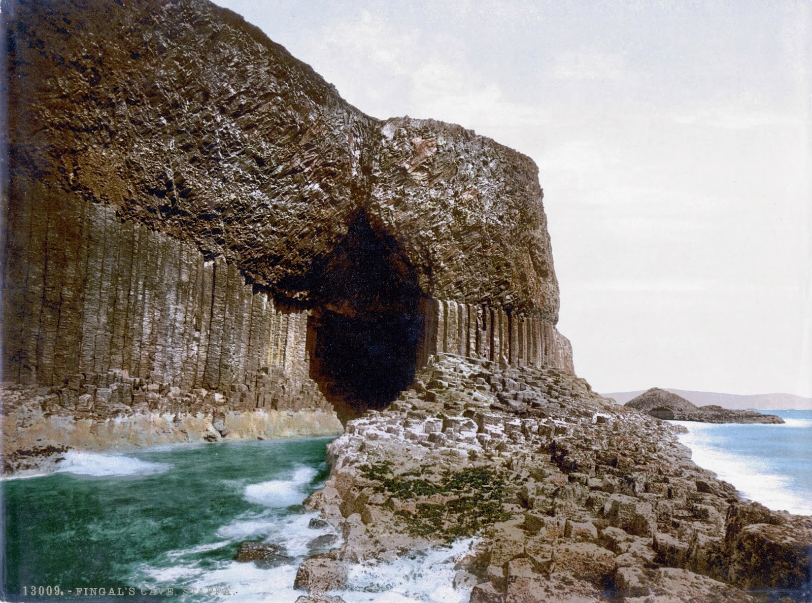
Fingal's Cave is a sea cave on the uninhabited island of Staffa in the Inner Hebrides of Scotland, part of a National Nature Reserve owned by the National Trust for Scotland. It became known as Fingal's Cave after the eponymous hero of an epic poem by 18th-century Scots poet-historian James Macpherson. 

It is formed entirely from hexagonally jointed  basalt columns within a Paleocene lava flow, similar in structure to the Giant Causeway in Northern Ireland and those of nearby Ulva.
In all these cases, cooling on the upper and lower surfaces of the solidified lava resulted in contraction and fracturing, starting in a blocky tetragonal pattern and transitioning to a regular hexagonal fracture pattern with fractures perpendicular to the cooling surfaces. As cooling continued these cracks gradually extended toward the centre of the flow, forming the long hexagonal columns we see in the wave-eroded cross-section today. Similar hexagonal fracture patterns are found in desiccation cracks in mud where contraction is due to loss of water instead of cooling.

ACTIVITIES AT FINGAL'S CAVE
- Cave exploration


SAMOA

TO SUA OCEAN TRENCH

LOTOFAGA, UPOLU ISLAND, SAMOA

Located in the village of Lotofaga ( population; 1,089) on the south coast of Upolu island in Samoa, is the To Sua Ocean Trench. An all-natural swimming hole with a large ladder and small dock, visitors can pay a fee ( $ 15 for adults, $6 for children 7-15, free for kids under 7 ) to access the 30 meter ( 98 ft) deep hole.


The island of Opolu was formed by a massive basaltic shield volcano. With an area of 1,125 km square kilometers (434 sq mi) and a population of 135,000, it is the second largest in geographic area and the most populated of the Samoan Island. Samoa gained its independence from New Zealand in 1962. To Sua Ocean Trench is open all wekk from 7am to 6 pm.


To Sua actually means a " Gigantic Swimming Hole". It is believed that lave field blow holes making these tide pools and walking paths along the shore and near the ocean's edge. It is about 30 metes down from the ground level, one must climb down a long ladder to the natural pool.


ACTIVITIES AT TO SUA OCEAN TRENCH

Swimming in the natural pool.


VIETNAM

SƠN ĐOÒNG CAVE

QUANG BINH PROVINCE, VIETNAM

Son Doong Cave is world's largest cave, located in Son Trach, Bo Trach District, Quang Binh province, Vietnam. It is found by a local man named Ho Khanh in 1991 and was recently discovered in 2009 by British cavers, led by Howard Limbert. The name " Son Doong' cave means " mountain river cave". It was created 2- 5 million years ago by river water eroding away the limestone underneath the mountain where teh limestone was weak, the ceiling collapsed creating huge skylights. Son Doong cave is more than 200 meters wide, 150 meters high, and approx 9 kilometers long, with caverns big enough to fit an entire city street inside them, twice as large as Deer Cave in Malaysia ( currently considered the world's largest with 90 meters wide, 100 meters high and 2 kilometers long ). Son Doong cave was classified as the largest cave in the world by BCRA ( British Cave Research Association) and selected as one of the most beautiful in the globe by the BBC news.


This tiny jungle, nickname the "Garden of Edam" that looks like "Pearl of Mountain"

Son Doong cave is hidden in rugged Phong Nha- Ke Bang National Park in Quang Binh province near the border with Loas, the cave is part of a network of 150 or so caves, many still not surveyed, in the Annamite Mountains. It is very difficult to travelers. During the first expedition, the team explored two and half mileso f Son Doong cave before a 200- foot wall of muddy calcite stopped them. They name it the Great Wall of Vietnam. Above it they could make out an open space and traces of light, but they had no idea what lay on the other side. A year later, they have returned- seven hard- core British cavers, a few scientists, and a crew of porters- to climb the wall, if they can, measure the passage and push on, if possible, all the way to the end of the cave.


ACTIVITIES AT SON DOONG CAVE

Cave exploration


River in Son Doong Cave


CHINA

ZHANGYE DANXIA LANDFORM

GANSU PROVINCE, CHINA

The Danxia Landform refers to various landscapes found in southeast and southwest China that consist of a red bed characterized by steep cliffs. It is unique type of petrographic geomorphology found in China. Danxia Landform is formed from red coloured sandstones and conglomerates of largely Cretaceous age. The landform look very much like karst topography that forms in areas underlain by limestones, but since the rocks that form danxia are sandstones and conglomerates, they have been called "pseudo-karst" landforms.


The first studies were conducted on what are now referred to as Danxia landforms were conducted at Mt. Danxiashan, located near Shaoguan, China. In the 20s and 30s, Chinese geologists made an effort to learn more about these interesting geomorphic structures. Similar in looks to karst topography, danxia landforms are made up uplifted continental crust that has been faulted and eroded, exposing large scarps of layered rock, red in color.


Danxia landforms cover several provinces in southeast China. Taining County, Fujian Province, has very good examples of "young" danxia landforms wherein deep, narrow valleys have been formed. As the landform get older, valleys widen and one gets isolated towers and ridges. The danxia landform is named after Mount Danxia, one of the most famous examples of danxia landform. A very peculiar feature of danxia landscape is the development of numerous caves of various sizes and shapes. The caves tend to be shallow and isolated, unlike true karst terrain where caves tend to form deep, interconnecting networks. In 2010, several danxia landscapes in southern China, with a general name of " China Danxia", were inscribed as a World Heritage Site. The six inscribed danxia landform areas are Mount Langshan and Mount Wanfoshan, Mount Danxia, Taining and Guanzhishan, Mount Longhu and Guifeng, Fangyan, Mount Jjanglang and Mount Chishui. The total core area of 6 region above is 73945 ha, and the total buffer area is 65446 ha.


ACTIVITIES AT DANXIA LANDFORM

HIKING

Hiking in the Danxia Landform areas, and made visits to nearby temples, caves and grottoes, and the Han Dynasty Great Wall in Jiayuguan.


UKRAINE

TUNNEL OF LOVE

KLEVAN, UKRAINE

Tunnel of Love is a beautiful spot in Klevan, Ukraine. A three kilometer railway section leads to the fibreboard factory. 

The train goes three times a day and delivers wood to the factory. However, the trees make a green corridor, which attracts many couples, as well as photographers for its eye catching evenue.

It is said that if you and your beloved come to the Tunnel of Love and sincerely make a wish, it will come true. This might be a new romantic place to discover.

Tunnel of Love in Klevan, Ukraine is the name given by the local people to this fairytale track. It is not everyday, you get in the train and find yourself surrounded by natural green arches, which is why make the sight of Tunnel of Love special.


An unused railway track in the small Ukrainian town of Kleven (which lies some 350km from Kiev) has naturally transformed itself into a romantic paradise for couples.
The track, which is known locally as The Tunnel of Love, is becoming an increasingly common spot for couples, particularly during spring, when a huge canopy of trees along the track grows over either side to form an arch. This arch stretches for up to three kilometers and looks like a green tunnel of trees and couples wishful of a few moments of romantic solitude are often seen strolling around.
However, the railway track is not completely out of use. According to a Daily Mail report, the tunnel is actually a part of a private railway serving a fibreboard factory in eastern Ukraine near Kleven. The train carrying logs chugs along the tunnel, or rather through it, thrice a day. That occasional activity is what, perhaps, prevents the trees from growing in the middle of the track, allowing the tunnel to remain as it has through the year.
The tunnel of trees is so dense it is difficult to see outside from within the structure and the natural light that penetrates the canopy from above makes the space soothingly dark.
However, there is not much attention given to the tunnel as a tourist attraction despite the obvious potential and the fact it is a naturally occurring space. So far, only locals really know of the place but a number of photographs surfacing in recent months suggest the tunnel could soon become a location synonymous with the idea of love, much as the Taj Mahal in India and the cities of Paris and Venice in France and Italy
ACTIVITIES AT TUNNEL OF LOVE

1. Walking along the Tunnel of Love


2. Get in the train and sightseeing along the Tunnel of Love


TURKEY

CAPPADOCIA

CENTRAL ANATOLIA, TURKEY, EUROPE

Cappadocia is an area in Central Anatolia in turkey best known for its unique moon-like landscape, underground cities, cave churches and houses carved in the rocks.

The Cappadocian Region located in the center of the Anatolian Region of Turkey, with its valley, canyon, hills and unusual rock formation created as a result of the eroding rains and winds of thousands of years of the level, lava- covered plain located between the volcanic mountains Ercives, Melendiz, and Hasan as well as its troglodyte dwellings carved out of the rock and cities dug out into underground, presents an otherworldly appearance. The eruptions of these mountains which were active volcanoes in geological times lasted in 2 million years ago. A soft tufflayer was formed, 150 m in thickness, by the issuing lavas in the valley surrounded by mountains. The rivers, flood water running down the hillsides of valley and strong winds eroded the geological formations consisting of tuff on the plateau formed with tufflayer, thus creating bizarre shapes called fairy Chimneys. These take on the names of mushroom shaped, punnacled, capped and conic shaped formations. The prehistoric settlements of the area ore Koskhoyuk (Kosk Moound) in Nigde, Aksaray Asikli Mound, Nevsehir Civelek cave and, in the southest, Kultepe, Kanis and Alisar in the environs of Kayseri. This area with unusual topographic characteristics was regarded as sacred and called, in the Scythian/ Khatti language, as Khepatukha, meaning "the country of the people of the chief god Hepat", although there are more poetic claims on the origin of the region's name, such as the Old Persian Katpatuka, which allegedly means "the land of beautiful horses".


CITIES IN CAPPADOCIA

1. Nevsehir - The main province of Cappadocia
2. Urgup - The biggest town and heart of Cappadocia
3. Goreme - Cave Houses built into the Fairy Chimneys
4. Uchisar - The highest point of the region with it's natural rock castle
5. Avanos - Pottery town which is divided into two by the longest river of Turkey (Kizilirmak)
6. Ortahisar - A small village famous with it's rock castle
7. Mustafapasa - Old Greek village

ACTIVITIES AT CAPPADOCIA

HIKING
Following the paths along the valleys is an amazing (and free) option. Check with your hotel owner or the tourist office for a map of the area with suggested walks and trails. There are several nice loops on packed dirt, sand and rock, that maintain a constant elevation and pass through the scenic valleys.

GUVERCINLIK (PIGEON) VALLEY
You can hike the Pigeon Valley between Goreme and Uchisar. The 4 km trails starts from the road near the Ataman Hotel on the south side of Goreme or on the paved road on the north side of the hill where Uchisar Castle sits in Uchisar. Both trailheads are signed. Stick to the more traveled trails and you will have no trouble finding your way on this moderately hilly hike. The path through the valley offers spectacular views of the natural cliffs and the man- made caves and passes through a few tunnels carved into the rock.

HOT AIR BALLOON TOURS
Are one of the most popular activities in Goreme and The oldest company Goreme Balloons Typically lifting off at sunrise, these rides last about an hour in the air and literally o wherever the wind may blow in the Cappadocia Valley. The balloon baskets holds around 20 people with the pilot riding air currents much like a boat, floating down the valleys, often below the ridge line and quite close to the chimney rocks. It's fantastic ride and if you've ever has the urge to splurge on a balloon ride, this would be the place to do it. There are 15 balloon companies in the region.


CROSS GOLF
Cappadocia is a national park and its natural environment must be protected for everyone to enjoy today and in the future. Cross Golf uses the natural features of the landscape to challenge even the most experiences golfer. The fairy chimneys, fascinating rock formations and flora and fauna in the unique environment of Cappadocia remain unaffected by Cross Golf.


Tuesday, March 11, 2014


BELIZE

GREAT BLUE HOLE

LIGHTHOUSE REEF, BELIZE CITY, BELIZE


The Great Blue Hole is a large submarine sinkhole off the coast of Belize. It lies near the center of Lighthouse Reef, a small atoll 70 km (43 mi) from the mainland and Belize City. The hole is circular in shape, over 300m (9984 ft) across and 124 m (407 ft) deep. It was formed during the several episodes of quaternary glaciation when sea levels were much lower. Analysis of stalactites found in Great Blue Hole shows that formation took place 153,000; 66,000; 60,000; and 15,000 years ago. As the ocean began to rise again, the caves was flooded. The Great Blue Hole is a part of the larger Belize Barrier Reef Reserve System, a World Heritage Site of the United Nations Educational, Scientific and Cultural Organization (UNESCO).


The Blue Hole is located 45 miles due east of Ambergris Cave and is located of Lighthouse Reef Atoll. The Blue Hole is accessible from Ambergris Cave by several operators whom offers full day trips departing several times weekly. It is also accessible from Long Cave Island at Lighthouse Reef with Huracan Divers. The Blue Hole of Belize is unique and is the only Blue Hole that can be actually be seen from the space with the naked eye. It was originally an above ground cave and as the water levels rose the weight of the water caused the roof to collapse and from an almost perfect circular hole.

The Blue Hole is 460 ft and 1000 ft in diameter.

ACTIVITIES AT GREAT BLUE HOLE

Blue Hole days trips depart from Ambergris Cave at 5.30 am and takes approx 2 hours 30 minutes depending on the weather. Trips sometimes pick up at Cave Caulker and the time is about the same to get to the Blue Hole. The Blue Hole trip from Long Cave at Lighthouse Reef with Huracan Divers takes approximately 15 minutes, and you need to be staying at Huracan or one of the other two options on the island.


The Blue Hole is more of a dive destination but is also offers excellent snorkeling around the rim of the hole. The trip is not cheap and costs $250.00 for a day trip and includes 3 dives, light breakfast, lunch, soft drinks and snacks, if you are a snorkeler, you are looking at about $165.00 you can decrease those rates if you use Belize Dive Discounts, as the offer a 20% discount and you can choose which operator you want to use.

Some of the dive shops that offer a full day trip to the Blue Hole are Amigos Del Mar, Aqua Dives and from May 1st 2010 Belize Dive Connection. It is a long day but a great day and visitor will enjoy a great day of adventure.


It can also be dived with Huracan Divers as part of 3, 4, or 7 night package staying at their lodge on Long Cave Island, Lighthouse Reef from where it is only a 15 minute boat ride and you can be the 1st boat on site, returning to the lodge after the dive for breakfast before your 2nd dive.
NEW ZEALAND

WAITOMO GLOWWORM CAVES

WAITOMO, NORTH ISLAND, NEW ZEALAND

The Waitomo Glowworm Caves attraction is a cave at Waitomo on the North Island of New Zealand, known for its population of glowworms, Arachnocampa luminosa. This species is found exclusively in New Zealand. They are found the size of an average mosquito. Glowworm or Arachnocampa luminosa are tiny, bioluminescent creatures that produce a blue-green light. This cave is part of the Waitomo Caves system that includes the Ruakuri Cave and the Aranui Cave.

The Waitomo Glowworm Caves were first explored in 1887 by local Maori Chief Tane Tinorau accompanied by an English surveyor Fred Mace. Local Moari people knew of the Caves existence, but the subterranean caverns had never been extensively explored until Fred and Tane went to investigate. They build a raft of flax stems and with candles in hand, floated into the cave where the stream goes underground.

As they entered the caves, they came across the Glowworm Grotto and were amazed by the twinkling glow coming from the ceiling. As they travelled further into the cave by poling themselves towards an embankment, they were also astounded by the limestone formations.


Jubilant at their discovery, they returned many times to explore further, and on one independent trip, Chief Tane discovered the upper level entrance to the cave, which is now the current entrance. By 1889, Tane Tinorau had opened the cave to tourists. Tane Tinorau and his wife, Huti, started leading groups through the cave for a small fee. In 1906, the administration of the cave was taken over by the government. They now receive a percentage of the cave's revenue and are involved in the management and development of the cave.

ACTIVITIES AT WAITOMO GLOWWORM CAVE

GUIDED TOUR AND BOAT RIDE

The guided tour through the Waitomo Glowworm Caves brings the visitor through three different levels and begins at the top level of the cave and the Catacombs. The levels are linked by the Tomo, whoich is a 16 m vertical shaft made of limestone. The second level is calles the Banquet Chamber. This level is where early visitors stopped to eat and there is evidence of this in the smoke on the ceiling of the chamber. From here it may be possible to link back to the upper level to see the largest formation called the Pipe Organ but on busy days, this area is closed to the public because the build-up of carbon monoxide may be hazardous.


The third and final level goes down into the Cathedral, demonstration platform, and the jetty. The Cathedral is an enclosed are with rough surface, now paved, and is about 18 m high, giving it good acoustics. A number of famous singers and choirs have performed here including Dame Kiri Te Kanawa.

The tur concludes with a boat ride through the Glowworm Grotto. The boat takes the visitor onto the underground Waitomo River where the only light comes from the tiny glowworms creating a sky of living lights.


MEXICO

THE SACRED CENOTE 

CHICHEN ITZA, YUCATAN PENINSULA, MEXICO

Cenotes are natural pits or sinkholes resulting from the collapse of limestone bedrock that exposes groundwater underneath. They are especially associated with the Yucatan Peninsula of Mexico, which is primarily made up of porous limestone. For millions of years, rainfall slowly ate away at the limestone and a huGe system of underground caves and caverns was formed. Many filled with water from the rain or from the underground water table. When the roof of a water filled cave collapses, a cenote is born. There are an estimated 7,000 cenotes in the Yucatan Peninsula.


Cenote comes from the Mayan word "dzonot" or "ts'onot" which means sacred well, and has great significance for the Maya. First, they represented the main water supply in a land that has no surface water bodies and suffers long dry seasons. As a consequence, all Mayan villages were build in the vicinity of a cenote, in order to secure a permanent water supply. Second, cenotes were also important for religious reasons. They believed cenotes to be portals to the underworld and a way to communicate with the Gods. Archaeological research has found evidence of religious ceremonies that took place in or around cenotes, including human sacrifices.


While the best-known cenotes are large open water pools measuring tens of meters in diameter, such as those at Chichen Itza, the greatest number of cenotes are smaller sheltered sites and do not necessarily have any surface exposed water.


Cenote water is often very clear, as the water comes from rain water filtering slowly through the ground, and therefore contains very little suspended particulate matter. This have attracted swimmers and cave divers from around the world who have documented extensive flooded cave systems, some of which have been explored for lengths of 100 km or more.

Some Cenotes have been turned into public swimming pools of sorts. One of the best examples is the Cenote Zaci, located in Valladolid. Another cenote with some tourist infrastructure is the Cenote San Ignacio, in Chochola. This cenote is artificially lit and has an adjoining restaurant and other services that make for a more comfortable visit. Finally, the facilities at Cenote Sambula, in Motul, were recently remodeled.

ACTIVITES AT CENOTE

The activities that can be done by the tourist is cave divers and swimming in the cenotes.